Maps

New book filled with marvelous maps

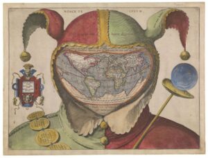
If you’re a serious traveler, you likely love maps.

And if you love maps, you’ll love the maps in a new book from the National Maritime Museum in Greenwich, England that celebrates the art of atlases with a look inside the museum’s collection of maps, globes, and map-related ephemera.

A is for Atlas: Wonders of Maps and Mapping, is a highly illustrated celebration of cartography from the thirteenth century to today.

Celestial globe, unknown maker, first half of the 17th century

The book draws on the museum’s collection of more than 40,000 maps, charts, globes, and atlases, including a sixteenth-century map of the world replacing the face of a jester, a nineteenth-century inflatable globe, and a twentieth-century waterproof map that saved lives during the Second World War.

Fool’s Head World Map, by unknown artist, around 1590
 
Inflatable Globe, George Pocock, 1830

The oldest object in the book is a manuscript map of Mesopotamia by Abu Ishaq Ibrahim ibn Muhammad al-Farisi al-Istakhri, dated before 1282. Mountain ranges are illustrated in a deep red with floral and geometric patterns, while the rivers Tigris and Euphrates flow across the page in a majestic blue.

Islandia, Abraham Ortelius and Anders Vedel, 1585

The most recent object is a football globe made for Mark Wallinger’s First World War centenary artwork, One World by Mark Wallinger. This 2018 football is a photographic representation of the Earth as seen from satellite imagery. This globe was commissioned to mark the centenary of the First World War, commemorating the ‘Christmas Day ceasefires’ that took place on the Western Front in 1914.

One World, Mark Wallinger, 2018

Rather than approach the collection chronologically, A is for Atlas draws on the collection in twenty-six themes, including ‘commemoration’, ‘manuscript’, ‘sea monsters’ and ‘treasure’.

The book also shows the results of an investigation into a nineteenth-century globe. An endoscope was fed through a hole in a Newton & Son terrestrial table globe from 1842, offering Dr Barford an unusual view – the inside of a globe. The investigation revealed proof pages from various books of the Bible lining the inside and supporting the papier-mâché hemispheres.

All photos courtesy National Maritime Museum, England

Maps for sale at Seattle-Tacoma Int’l Airport

This delights me to no end. And not just because it is at my home airport.

On Friday – just in time for the long holiday weekend – a new store selling maps, globes and other fun travel-related items opened at Seattle-Tacoma International Airport.

SEA_Metsker Maps

Metsker Maps has cartography roots in Seattle dating back to 1880 and a popular store in downtown Seattle at the Pike Place Market. The shop sells maps of all kinds, globes, books, guides, travel accessories and children’s items.

Modern-day map apps are useful and all that, but “maps tell us where we are, remind us of where we have been and inspire new adventures,” said Metsker Maps president Jay Brown.

I’ve got a trip coming up in a few days and I’m already planning on heading to the airport extra early so I can visit the store. One map I hope they have in stock is a scratch off world map .

“No need for map pins here – just scratch the country you have been to and the colorful underlying layer is revealed!”

I want to buy this map, unfold it at the gate for my international flight and see if between me and my fellow travelers we’ve got the whole world ‘scratched.’

Souvenir Sunday: maps

On Sunday here at StuckatTheAirport.com, we take a look at the fun, inexpensive things you can buy at airports. Things that I find and things that you find.

This week, a few items I wish we could find at airports…

First up, playing cards with maps on them.

On the Muji website I found snazzy-looking map-themed playing cards – London, Paris and Tokyo.

Probably not useful for making your way through a city, but entertaining and easy to pack.

These Crumpled City maps, found on the Palomar site, though would be totally useful.

They are soft, indestructible and invite being crumpled. And they come in a bag.

Available cities: Amsterdam, Barcelona, Berlin, Chicago, Copenhagen, Edinburgh, Florence, Hamburg, Helsinki, Lisbon, London, Milan, New York, New Zealand (Auckland, Wellington, Queenstown), Oslo, Paris, Rome, San Francisco, Stockholm, Sydney, Tokyo, Toronto, Venice

I want them all!

Souvenir Sunday: What would Alice do?

Although she didn’t really mean to, Alice – of Alice on Wonderland fame – ended up going on one of the wildest travel adventures ever “documented.”

Want to see the original notes of her journey?  The British Library happens to have the first edition of Alice’s Adventures in Wonderland, as well Galileo’s letters, Leonardo Da Vinci’s notebooks, manuscript scores from classical composers such as Handel, Purcell, Mozart and Schubert, and lots more.

Can’t just pop over to London to take a look-see? The next best thing might just be the British Library’s new smartphone app (iPad, iPhone, Android) which lets you page through more than 100 of the library’s treasures, including Jane Austen’s teenage writings, maps, scientific papers, an original Magna Carta 1215 and audio clips from historical figures such as Nelson Mandela.

The app isn’t free; it costs $3.99 for iPhone, iTouch and Android ($5.99 for the iPad), but there’s an introductory offer of $1.99 ($3.99 for the iPad) through January 24, 2011.

Not sure it’s worth 2 bucks?  Here’s a really lovely video that includes a sampling of what you’ll get to see on the app.

I’ve downloaded the program, but haven’t had much time to play around with it. When I do, I hope I’ll find photos and more information the world’s smallest atlas and some of the other teeny tiny books in the British Library’s collection.

Tidbits for travelers: airport taxi sharing, Austin art, and marvelous maps

Even with all the free deals you can find on NYCGO.com, a trip to New York City can be quite spendy. So it’s welcome news that the Wall Street Journal reports that New York’s Taxi and Limousine Commissioner is thinking of expanding a popular, cost-saving taxi sharing program to LaGuardia Airport (and possibly JFK) and he Port Authority bus terminal.  Good idea!

Art at Austin Airport


(Collin Scott’s clay bust titled, “Neolithic Cuneiform Subconscious.”)

The Austin Bergstrom International Airport (AUS) has rolled out yet another intriguing art exhibit. This one features work from the Lost Pines Artisan Alliance (LPAA), including a wide variety of three dimensional media ranging from ceramics and cast bronze, to wood and fabric fibers.  The exhibit is on display through July 14, 2010, post-security in the concourse glass pylons located between Gates 7 – 11.

Grab a map for London

And there are two exhibitions about maps in London right now that have me checking airfares and flight schedules.

Drawing from a collection of more than four million maps and loaned specimens, Magnificant Maps: Power, Propaganda and Art, at the British Library, shows off “80 of the largest, most impressive and beautiful maps ever made, from 200 AD to the present day.”

Among the treasures on display are the 17th-century Klencke Atlas (above), which is said to be the world’s largest book, and the world’s smallest atlas, which was created for Queen Mary’s dolls-house.

And in Creative Compass, at the Royal Geographical Society, artists Agnes Poitevin-Navarre and Susan Stockwell take inspiration from the society’s collection of more than one million maps, three thousand atlases and half a million photographs to create a map of Afghanistan made from US dollars, a map of Londoner’s aspirations and achievements,  a Victorian dress recreated with 19th century maps and other art pieces.

Magnificent Maps: Power, Propaganda and Art is at the British Library through September 19th, 2010. Admission: free. Creative Compass opens May 6th and runs through July 2nd at the Royal Geographical Society.  Also free.